Data, Reports, and Deliverables for NYSERDA 2015 SLAMM Project
![]()
Google Earth Tool Specifications
Download:
Basic Users Guide:
The Google Earth tool provides a user-friendly interface to illustrate the fate of current and potential new-marsh habitats.
A basic understanding of how Google Earth works will be helpful. (This product is not yet compatible with the new browser-based "Earth for Chrome")
To get started, download the zip file(s) using the link above. Extract the data into a folder on your computer. Double click on the KML file or open the KML files using Google Earth or Google Earth Pro.
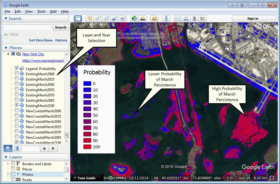
Maps are shown as probabilities because there is uncertainty in future SLR and marsh sedimentation responses. A high probability of marsh existence means that a marsh is likely to exist at a given date given all of these uncertainties.
The “Existing Marsh” layer is designed to describe the fate of currently-existing marsh in the future given uncertain SLR. Will the current marsh thrive or be permanently inundated by future water levels?
The “New Coastal Marsh” layer is designed to describe locations where marsh may migrate in the future, but does not exist now. This distinction is important for planning as dry lands may not be made available for marsh migration if they are private lands or have public uses. Walls or barriers may be built or fill may be added to prevent marsh migration.
You may zoom in to these maps to any level and turn on or off different data layers using the check boxes using the Google-Earth "Places" interface usually located on the left side of the screen. (Only one year should be selected at one time or layers may overlap.)
A legend option is provided at the top of the list describing the color gradient that is used to describe these probabilities. A red color on the map (90 for example) would mean that a marsh is 90% likely to inhabit a given location at a given date. A blue color means that the probability is much lower. Zero percent probability is not visible (shown as transparency) such as on developed lands, high lands, or open waters.
Detailed overview:
Rendered maps show the predicted fate of areas covered by marsh in 2008 (the date of the available initial land cover layer) and the potential location of new marshes given an uncertain future rate of sea-level rise (SLR). The maps provide spatial information of the probability that an area covered by marsh in 2008 is still a marsh (probability maps for existing coastal marsh systems) and an area that is not a marsh in 2008 will be marsh (probability maps for potential "new coastal marsh").
Probability maps were obtained by running the model for two hundred realizations with input parameters and SLR scenarios sampled from assigned uncertainty distributions that reflect measurement errors and/or lack of certainty. A high probability means that the marsh is not likely to be destroyed at that time despite uncertainty in SLR estimates and other input parameters. Low probability means the opposite. Similarly, the model also looks at the potential migration of marshes under uncertain conditions. A high probability means new marshes are very likely to colonize the parcel in question and a low probability means the opposite.
The layers are labeled "ExistingMarsh" and "NewCoastalMarsh" with relevant dates. An "existing marsh" layer with a date of 2025 would mean "probability that a marsh that existed in 2008 (based on existing wetland maps layers) will continue to exist in the year 2025" A "new marsh" layer with a date of 2025 would mean "probability that this location that did not have a marsh in 2008 will be a zone that new coastal marsh can migrate into." SLAMM does not predict that marshes will inhabit currently-developed lands (within the accuracy of the development data layer used).
Model results are available for 2008 or 2010 (model prediction of current conditions also called "time zero") along with projections for 2025, 2040, 2055, 2070, 2085, and 2100.
------------------------------------------------------------------------------------------------------------------------------------------------------------------------------------------------------------------------------------------
Advanced: For DMMT tool users only: New York City DMMT Case Study
DMMT Tool Users Only: The DMMT case study file allows a user to see the parcels evaluated in the "dynamic marsh management tool" case study. Each of the cumulative utilities calculated from 2016 to 2100 are also presented under the various adaptation scenarios examined. Utilities pop up by clicking on a parcel on the "places" toolbar or by clicking on a parcel on the map.
Adaptation scenarios calculated are as follows:
- NOMIGR: utilities calculated for each marsh parcel from existing marsh, assuming no additional migration
- MIGRUNDEV: utilities calculated if migration to undeveloped land is allowed
- MIGRALL: utilities calculated if migration to undeveloped and developed land is allowed
- REST1974: utilities calculated if marsh is restored to 1974 but no migration to dry land is allowed
- THINLAYER: utilities calculated for existing marshes under a regime of thin-layer deposition with no additional migration
DMMT results and parcels can be examined with the NYC uncertainty-analysis results discussed above overlaid. The "no migration" utility maps would correlate with the "existing marsh" results, and the "migration to undeveloped" results would correlate with the new coastal marsh results." Utilities presented are the aggregation of utilities from 2016 to 2100-- the units do not have meaning except when comparing one parcel to another.
Metadata: